MISHAP
In 'Mishap' I am looking at our increasing disconnection with landscape by re-visiting images I made over a twenty-five year period. I am not comfortable with the familiar, overused and cliched formulas of photography language in the depiction of landscape, rather I fell in to a trap and it has now become a means to an end.
The project draws from mostly commercial landscape photography, supported by uncorroborated texts. It is intended to be a hermeneutic investigation addressing notions of truth in photography.
A note on the texts:
Wikipedia, The Free Encyclopaedia has been used as a source for the captions, in support of photographs that may not be representative evidence of the truth.
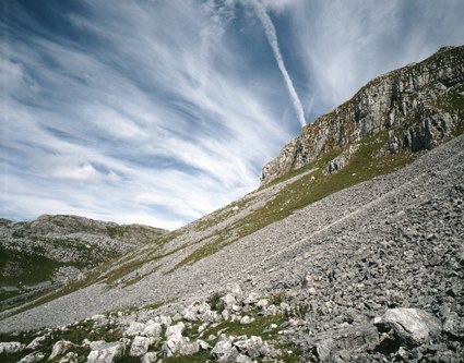
← Settle was part of the West Riding of Yorkshire. It is located in Ribblesdale, at the southern edge of the Yorkshire Dales, within a few miles of the Three Peaks. Immediately overlooking the town is Castlebergh, an impressive 300 feet limestone crag, and to the east is Malham with its tarn and limestone pavement scenery. The river provided the power for its former cotton mills, and is now being harnessed by the Settle Hydro, a micro hydroelectric scheme to provided 50kW of power to the National Grid.
The chemtrail conspiracy theory holds that some contrails are actually chemicals or biological agents deliberately sprayed at high altitudes for a purpose undisclosed to the general public. Versions of the chemtrail conspiracy theory circulating on the internet and radio talk shows theorize that the activity is directed by government officials. As a result, US federal agencies have received thousands of complaints from people who have demanded an explanation.The existence of chemtrails has been repeatedly denied by government agencies and scientists around the world.
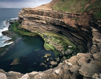
← Filey Brigg is to the north of Filey which is a small town and civil parish in North Yorkshire, England. Filey forms part of the borough of Scarborough and is located between Scarborough and Bridlington on the North Sea coast. Although it started out as a fishing village, it has a large beach and is a popular tourist resort. Until 1974 it was an urban district in the East Riding of Yorkshire.
According to the 2001 UK census, Filey parish had a population of 6,819. Filey is at the eastern end of the Cleveland Way, a long-distance footpath; this starts at Helmsley and skirts the North York Moors. It was the second National Trail to be opened (1969). It is also the northern end of the Yorkshire Wolds Way which starts at Hessle and crosses the Yorkshire Wolds. Filey is the finishing point for Great Yorkshire Bike Ride. The 70 mile ride begins at Wetherby Racecourse.
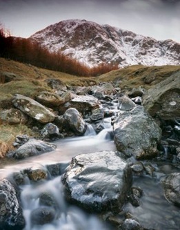
← Haweswater is a reservoir in the English Lake District, built in the valley of Mardale in the county of Cumbria. The controversial construction of the Haweswater dam started in 1929, after Parliament passed an Act giving the Manchester Corporation permission to build the reservoir to supply water for the urban conurbations of north-west England. At the time, there was public outcry about the decision, as the valley of Mardale was populated by the farming villages of Measand and Mardale Green and the construction of the reservoir would mean that these villages would be flooded and lost and the population would have to be moved. In addition, the valley was considered one of the most picturesque in Westmorland and many people thought it should be left alone.

PHOTOGRAPHER